English
 Ελληνικά
 Русский
Bicycle routes of Cyprus
For real bicycle lovers - 2 in Nicosia and 3 in Limassol
Cycling is a sport that can be done also at an amateur level and requires only a few things: a bike in excellent working condition, water, a spare tire, a cyclist (trying to reach, at least) in good physical shape and a road or a path to grow. And like all the sports, it's something that you learn, you never give up. Something that as a cyclist I confirm it. And after seeing the general cycling directions in Cyprus, the time has come to look at various cycling routes as proposed by various competent bodies or by the writer.
Lythrodontas - Kionia - Lythrodontas
According to data provided by the Cyprus Tourism Organization (CTO), the route starts from the village of Lythrodontas and passes through the Kyprovasa area, the village of Vavatsinia, the Kionia excursion area, the Machaira Monastery, Agios Onoufrios church and the Mandra tou Kambiou area, to return to the village of Lythrodontas again. The route covers a total distance of 45 kilometers, a current vertical height of 890 meters and a dirt road of an uneven surface at its longest length, characterised by strong uphill and short downhill runs. A 24-speed moped bicycle with front suspension is required.
Nicosia - Adelfoi Forest - Asinou
According to data provided by the CTO, the route starts from the northeast of Agios Mamas and passes through the villages of Paliometochos, Menikoikos, Kato Moni, Agia Marina, Capoura, Kannavia, Agia Irini and Spilia, to arrive at Asinou on a route 83 kilometers and a current vertical of 975 meters, which is characterised as difficult, with a steady climb of 2% on average and a higher coefficient not exceeding 5%. It concerns a mixed surface asphalted road and dirt road, and a 21-speed mountain bike is required.
Limassol - Amathus
According to data provided by the CTO, the route starts from the old port of Limassol, now Limassol Marina and headed east, through the coastal front of the Limassol Municipality and the Potamos Germasogeia and Amathousas, reaching the area of Agia Varvara Limassol, on a 11 kilometer and negligible route current height, easy for any type of bicycle, with asphalt paved road and motorway along its entire length.
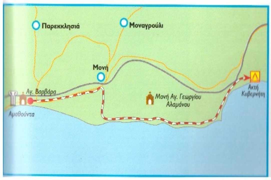
Amathus - Governor Coast
According to data provided by the CTO, the route starts from the Amathus area and headed east through the Monastery Cemetery and the river near the Monastery of Agios Georgios Alamanos, ends at the beach and camping site of Governor's Coast, through a 15 km and negligible current height, which is characterised by hard and uneven ground. This route requires a good quality 24-speed moped bike and front suspension. As far as the ground is concerned, if the first 5 km are excluded on an asphalt road at the beginning of the route, the rest is moved on uneven, rocky and clayey ground.
Limassol - Fasouri - Pachna - Limassol
According to data provided by the CTO, the route starts from Limassol traffic lights in Limassol, passing through the villages of Zakaki, Asomatos, Fasouri, Kourion, Ancient Stadium of Kourion, Ancient Sanctuary Apollo Hylati, Happy Valley , the villages of Paramali, Avdimou, Prastio, Agios Amvrosios, Civides, Souni, Kantou, Erimi, Kolossi, the Ancient Fortress of Kolossi and the villages of Fasouri, Asomatos and Zakaki, end up in the traffic lights of Limani (Port) in Limassol again. Although a relatively distant 77 km long and 660-meter vertical route does not have any particular difficulty, apart from some relatively uplifting, as well as a good quality asphalt road along the entire length of the route, it is therefore necessary speed bike.
The copyrights of the maps belong to the Cyprus Tourism Organization


 Posted by
Anastasios Anastasiou
Posted by
Anastasios Anastasiou