English
 Ελληνικά
 Русский
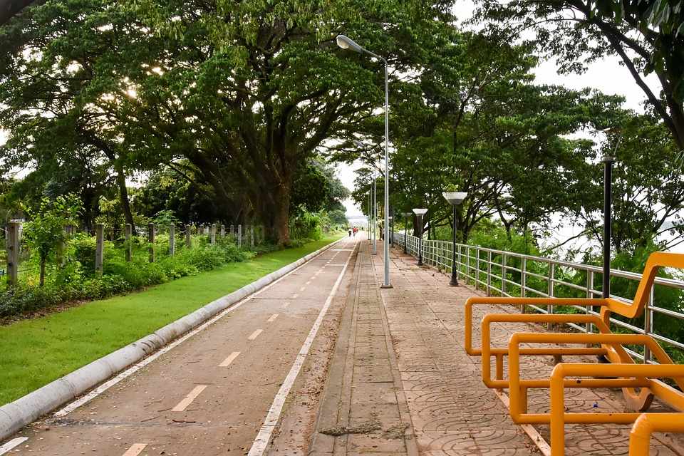
Bicycle routes of Cyprus
3 in Nicosia & Larnaka, 1 in Nicosia & Troodos & 1 in Kokkinochoria (Red Soiled Villages)
Cycling is a sport that can be done on an amateur level and requires only a few things: a bike in excellent working condition, water, a spare tire, a cyclist (trying to reach, at least) in good physical shape and a road or a path to grow. And like all the sports, it's something that you learn, you never give up. Something like a cyclist I confirm. And after seeing the general cycling rules in Cyprus, the time has come to look at various cycling routes as proposed by various competent bodies or by the writer.
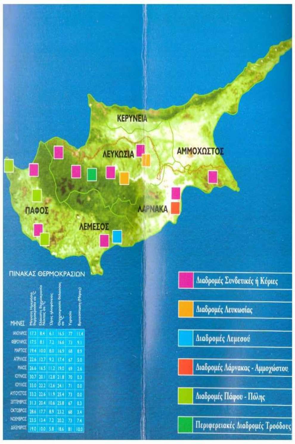
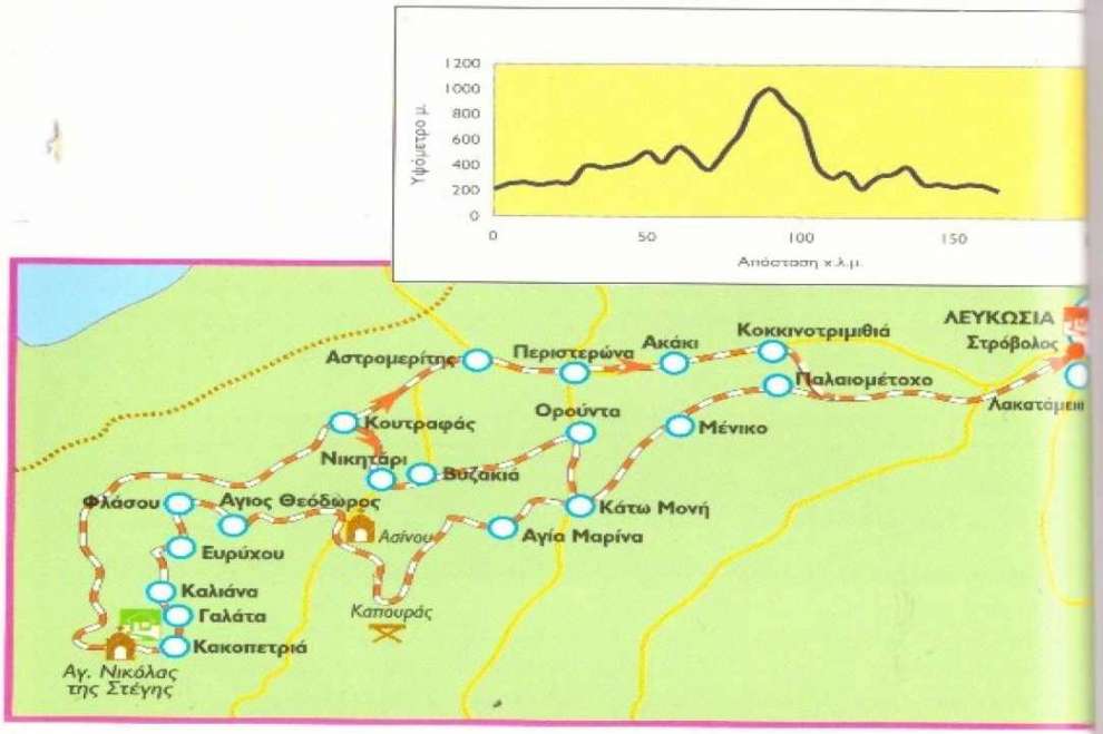
Nicosia - Solea Valley: According to data provided by the Cyprus Tourism Organization (CTO), this route starts from the Agios Mamas interchange roundabout in Lakatamia and passing through the villages of Agioi Trimithias, Paliometocho, Meniko, Kato Moni, Agia Marina, Kapouras, Asinou, Agios Theodoros, Flasou, Evrychou, Kaliana, Galata, Kakopetria, Aghios Nikolaos of Stegi church, Stavroulia and arrives at Koutrafa, from where returns through the villages of Nikitari, Vyzakia, Orounta, Kato Moni, Meniko and Paliometocho, to end again at the interchange roundabout of Agios Mamas, with a total distance of 165 kilometers and a current vertical height of 1380 meters, a high degree of difficulty, with steady climb, with an average climb of 2% and the highest ascent rate not exceeding 5%. A 21-speed climbing bike is required, while the road is a mixed surface, asphalt and dirt road.
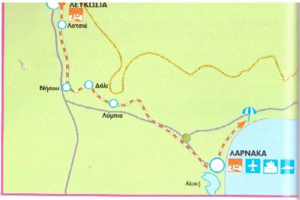
Nicosia - Tourist area of Larnaca: According to data provided by the CTO, this route starts from Nicosia and passes by Latsia Municipality, Nissou, Idalion Municipality, the villages of Limbia and Koshi and the Municipality of Aradippou, the traffic lights "Fire Brigade" and the roundabout "Port" in Larnaca and reaches the Larnaca Tourist area, with a total distance of 51.5 kilometers and a current vertical height of 100 meters, a minimum degree of difficulty, is offered for all types of bicycles with speeds, while the road is asphalted along the whole length of the route.
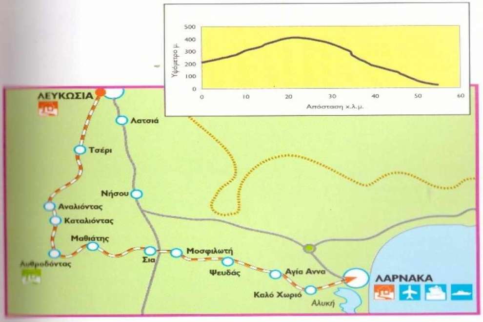
Nicosia - Lythrodontas - Mosfiloti - Larnaka: According to data provided by CTO, this route starts from Tseri roundabout in Strovolos and passes by Tseri Municipality and the villages, Analiondas, Lythrodontas, Mathiatis, Sha, Mosfeloti, Psevdas, Ayia Anna and Kalo Chorio, the Kalo Chorio roundabout and the "Fire Station" traffic lights in Larnaca to finish at Athens Avenue (Phinikoudes street), with a total distance of 55 km and a current vertical height of 195 meters, a minimum degree of difficulty, suitable for every bike at speeds. The road is be asphalted along the entire length of the route.
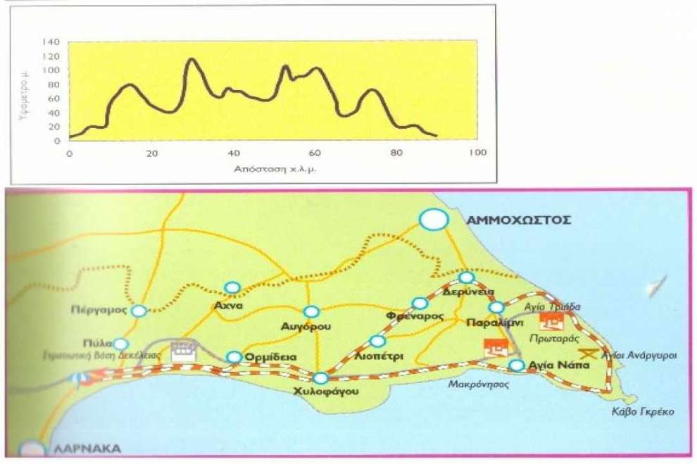
Round of Deryneia: According to data provided by the CTO, this route starts from Larnaka Tourist area and passes by Municipality of Livadia, the villages of Oroklini and Pyla, the Military Base and the Power Station of Dhekelia, the villages of Ormidia and Xylophagou, the Liopetri River, Makronissos beach, Agia Napa Municipality, Cape of Cave Greco, Protaras, Agia Triada beach and the Municipality of Paralimni to arrive at the Municipality of Deryneia, from where returns through the villages of Frenaros, Liopetri and Xylophagou, Power Station and the Military Base of Dhekelia, the Pyla and Oroklini villages and the Municipality of Livadia to finish again in Larnaka Tourist area through a total distance of 85 km, current vertical height of 260 meters and a minimum degree of difficulty. A road bike is required at speeds, while the road is asphalted along the length of the route.
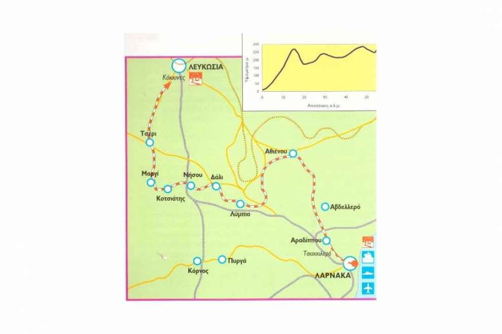
Larnaca - Athienou - Nicosia: According to data provided by the CTO, this route starts from the roundabout "Harbour" in Larnaca and passing through the Tshakkillero refugee settlement, Municipality of Aradippou, near the village of Avdellero, Municipality of Athienou, Lympia, Municipality of Idalion, the the villages of Nissou, Kotsiatis and Marki and the Municipality of Tseri, to reach the roundabout of Tseri in Strovolos through a total distance of 60 km, a current vertical height of 410 meters and a moderate degree of difficulty. A road bike is required at least 14 speeds, while the road is asphalted throughout the journey.
The copyrights of the maps belong to the Cyprus Tourism Organization.
 Posted by
Anastasios Anastasiou
Posted by
Anastasios Anastasiou